We have been watching the Colorado Springs news most evenings after work. Features about the graduation festivities at the US Air Force Academy have been shown for the last several days. Unfortunately, we were unable to get tickets to witness the the pageantry in person. So we decided to go to Colorado Springs to watch the show put on by the Thunderbirds, the US Air Force precision flying squadron, at the end of their graduation ceremony. We were on a hill just on the east side of I-25, about 4 or 5 miles from the campus, with hundreds of other spectators. The atmosphere was electric, similar to tailgating before a college football game. Some observers even had grills.
Here is a view of the main campus at the USAFA. The AF Chapel is the tall building on the right.
Falcon Stadium at a distance.
The air
show was supposed to begin immediately after the cadets tossed their hats
into the air after being dismissed at the end of the graduation ceremony. The six Thunderbird F-16's began their show as they flew over Falcon Stadium as the hats were tossed in the air as verified by the local news later that evening. As soon as the Thunderbirds passed overhead we heard the roar of the jet engines echoing through the mountains.
After all six planes flew over the stadium, two jets broke off the formation until the conclusion of the show about 30 minutes later. The formation of four jets with snow capped mountains in the background. What a majestic sight!
Each time the jets flew over the festivities, the formation was different.
Time to turn back.
Coming by upside down.
Four jets bunched in tight.
A postcard view of four F-16's.
A quick assent by a solo pilot.
All 6 fighters back together again.
The finale was the famed Delta Formation.
Many thanks to daughter Wendy for insisting that we needed a telephoto lens on our camera. We could not have captured these photos without that wonderful accessory.
What a thrilling end to a wonderful day. We are so thankful to live in a country where we can enjoy the many freedoms we have thanks to the men and women in our armed forces. Congratulations to the AFA Class of 2015!
The weather was warm and sunny for the first time this summer on one of our days off from work. We chose to hike up towards the historic landmark along I-25 in the town of Castle Rock. Castle Rock is a town about 7 miles north of our campground where we go to shop for groceries and other necessities. The classic view of this landmark was taken from the downtown area and overlooks the entire town. Obvious why the town is named Castle Rock.
This was the view of the Castle Rock from the parking lot of Rock Park. The local hiking booklet called the hike we were about to take "difficult".
Could "difficult" have been because of this warning sign at the trailhead?
More likely it was labeled "difficult" because of the many places where you had to climb a series of steep steps. Paul is shown on one of these sets of steps. We were serenaded by many birds all during our hike.
The views as we ascended towards the top were breathtaking. We never tire of looking towards the south to snow covered Pikes Peak, about 30 miles away. With all the rain we have had in Larkspur at 6600 feet above sea level, Pikes Peak (over 14,000 feet above sea level) has gotten lots of snow. The town of Castle Rock is in the foreground.
Even though most of the rocks were a dull gray in color, we found this colorful purple rock roughly cut from what or how we don't know.
This large boulder was along the trail. You can see its enormity with Paul (6' 1" tall) standing alongside it. We wondered how many thousands or millions of years ago these other rocks fell from the top of Castle Rock.
As we approached the top of the trail near the base of the Castle Rock itself, we could easily see the enormity of the this famous landmark. Look how steep the sides are. Around a bend Paul is dwarfed by the side of Castle Rock.
We walked around the base of Castle Rock admiring the many cliff swallows who constantly flew in and out of their nests in the sides of the rock. Ann was able to photograph one of these swift flying birds as it sat next to its nest. Many similar holes were found all around the Castle Rock.
A local hiker told us about a falcon nest above the whitewash portion of the rock face. But, despite how hard we looked, we never did see the falcon.
As we came around the backside of the Castle Rock, we could see just how hard the wind was blowing on top when we looked upwards towards the American flag on a flagpole at the summit.
As we returned down the trail to the parking lot, we spotted this pine tree with new growth. Spring must be about ready to turn into summer, finally.
We thoroughly enjoyed our hike in sunshine with warm temperatures reaching the 60's. Hopefully, the cool rainy weather in May will give way to lots of sunshine and more warm days as the calendar turns to June.
We took a last photo of Castle Rock as we were exiting the park, and you can see the rain clouds beginning to roll in. Yes, it rained again a little while later. As we were preparing dinner later in the afternoon, the roof of the
motorhome was pelted by rain and more hail. This was the 3rd day in a
row we had hail, apparently a common occurrence here in the foothills of the Rockies in late springtime.
While this hike was labeled "difficult", we compared it to what was called "moderate" in Grand Teton National Park when we first began our workamping adventures six summers ago.
Major League Baseball is considered "The Show" by players, managers, coaches, and fans. We decided to go see the Colorado Rockies play the Philadelphia Phillies on a cool and cloudy but dry day in late May. When Paul was growing up in Philadelphia, the Phillies were his team.
Coors Field, the home of the Rockies, has one unique characteristic that no other major league ballpark has. Near the top of the upper deck is a row of purple seats which designate these seats as exactly one mile above sea level.
Paul decided to try a purple seat.
Another unique characteristic of Coors Field is a "batters eye" that is green trees and vegetation. Most baseball stadiums use a plain green wall or backdrop to aid the batter in seeing the baseball as it leaves the pitcher's hand. In this area,the fountains shoot water after a Rockies homerun.
A view without the fountains. You can see the Phillies bullpen off to the right under the Wells Fargo sign.
Notice the umpires are all wearing jackets. The Colorado Rockies logo looks good behind homeplate.
This photo of the Rockies scoreboard taken just prior to the first pitch at 1:10 on a cloudy afternoon shows the temperature to be 51 degrees. Look just to the right of the Coca Cola lettering in the lower left-hand portion of the photo to see the temperature. Also notice the lights are turned on for a day game!
Another unique feature of Coors Field is the view of the Rocky Mountains beyond the left field stands. In this photo you can barely see the mountains due to the clouds and some fog.
One more view of the mountains.Yes, there were a lot of empty seats but we had a good time nonetheless. Our ticket cost $27 to sit in the upper deck above first base. However, we also got a $10 credit at any concession stand.
We enjoyed our time at Coors Field and hope to be back later this summer. The only thing that wasn't fun was the drive back to Larkspur. It took us well over 90 minutes to return, while it only took about 40 minutes to get the ballpark. Denver rush hour traffic reminded us of other large cities like Atlanta and Dallas. On our next trip to Denver, we are considering using their light rail system to get to the ballpark and not have to experience bumper to bumper crawling traffic again.
We have traveled to Colorado several times on vacations, but we have never visited the Royal Gorge Bridge and Park, near Canon City, Colorado. We were surprised that there is so much more to see and do than just walk across a bridge.
This
is a view of the Royal Gorge Bridge with a gondola heading to the south
rim of the Gorge. The bridge was built in 1929 and is one of the
world's highest suspension bridges, towering over 1,000 feet above the
Arkansas River.
Here
is another view of the bridge along with a view of the Arkansas River
below. Unlike a canyon, a gorge is narrower at the bottom than the top.
The Royal Gorge is a mere 50-60 feet wide at the bottom.
Lt. Zebulon Pike, for whom Pike's Peak is named, was the first recorded American explorer to discover the Royal Gorge, arriving in this area in December,1806. Previously, the Ute were Native Americans most identified with the Royal Gorge region.
We hurried to get in line for the aerial gondola ride that travels from the visitors' center to the other side of the Gorge. You can see the temperature wasn't very warm as we waited for our ride.
There was a hummingbird feeder on the gondola dock for us to watch as we waited our turn. We marveled at how quickly these tiny birds would fly in, get some nourishment, and then fly off, all while making humming sounds.
This view from our gondola down into the gorge gives you an idea of just how deep and narrow this gorge is. We were 1200 feet above the Arkansas River at this point. If you look closely, you can see railroad tracks to the right of the river. In the early 1900's, visitors came here by train. Part of the railroad track bed through the Gorge is over a hanging bridge. 90% of the bridge is suspended over water, as the Gorge was
too narrow, and flat land ran out. The
Hanging Bridge was constructed in 1879 so trains could pass through the
Royal Gorge. It must have been thrilling to ride through such a narrow place in a train. What a way to see nature at the turn of the 20th century.
After we finished our gondola ride, we were able to get a photo of the two gondolas passing each other. The journey in the gondola from one side of the gorge to the other is 2,300 feet. We felt the swaying motion of the gondola as the wind hit it, similar to riding a gondola to the top of a mountain at a ski resort. The ride across the Gorge was the highlight of our trip.
We enjoyed viewing the many artifacts saved during the original construction in the Plaza Theater, which was built in 1929 when the bridge was first opened. You can see now thick this cable is, containing thousands of wires needed to hold up the bridge that spans the Gorge.
The bridge cables are anchored at each end into tons of concrete.
This view from an observation platform on the south side of the gorge shows the complexity and steepness of the red granite rock sides of the Gorge.
As we hiked to get to the edge of the bridge, we found this Plains prickly pear cactus growing on the south rim.
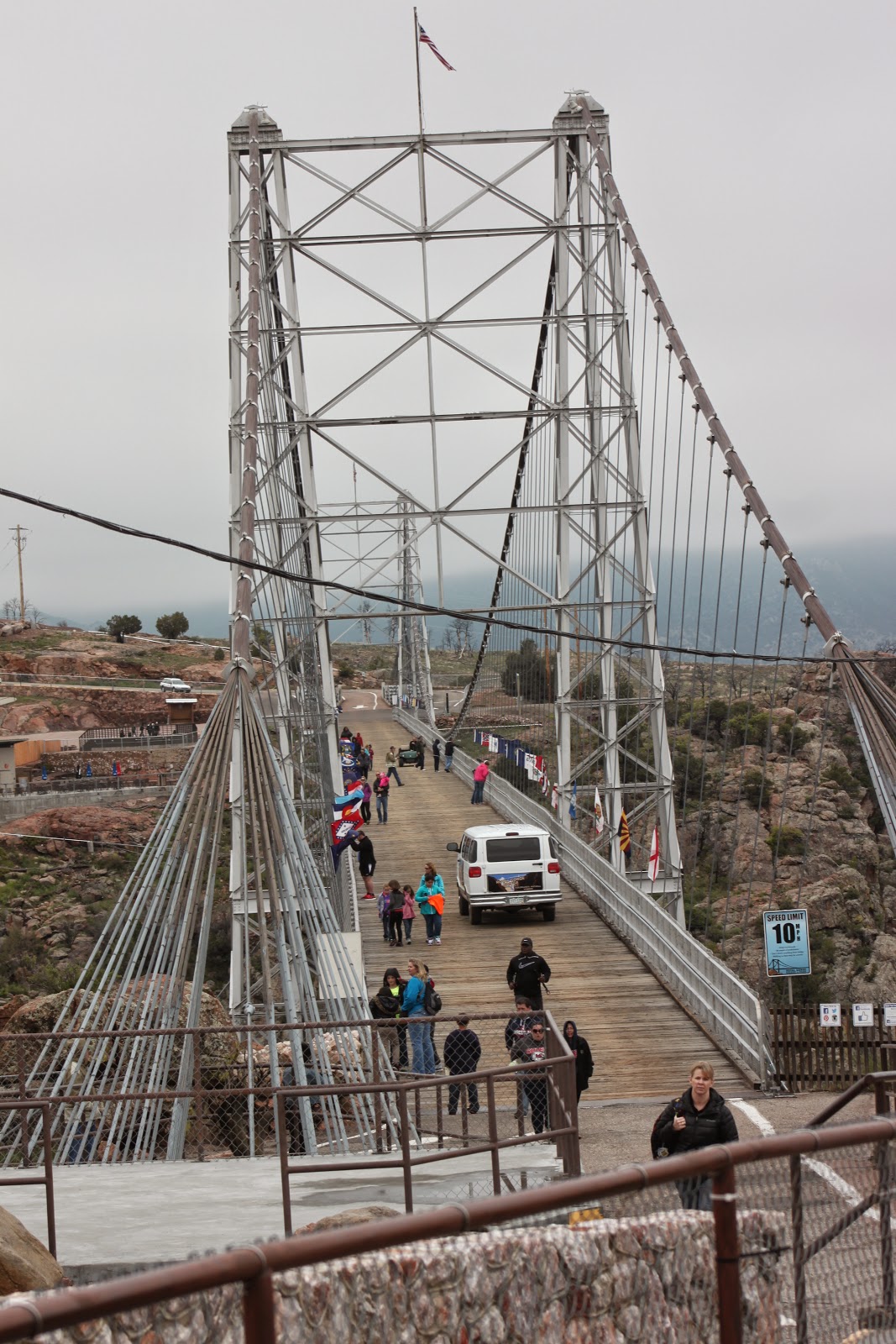
We explored the south rim and then walked back across the Royal Gorge Bridge to the north rim. We could feel the bridge sway in the wind as we walked across the bridge. There are flags from all 50 states flying from the bridge. Paul is shown with both the Florida flag and the Colorado flag. Notice how windy it was the day of our visit.
While
walking across the bridge, we spotted some Lupine and cactus growing together in the granite wall of the the north rim.
Once across the bridge, we looked back to see other visitors crossing the bridge. The white van is used to transport physically challenged guests to the other side of the Gorge.
Outside the visitors center is one of the three waterclocks in the world. Cascading water drives the wheels that allow the clock to display the exact time of day.
We knew that this area was devastated by a wildfire on June11, 2013, and the facilities surrounding the bridge had to be rebuilt. We noted on the local news that the facility had been mostly rebuilt and had a grand re-opening earlier in May 2015, so we were eager to see what the attraction was all about.
A few of the burned trees remain, with the hilly landscape barren except for new low bushes.
A tribute
to the recovery efforts after the fire can be found in the Legacy Wall
on the east side of the new visitors center. While much of the park was
destroyed in the fire, the Bridge stood unscathed except for these
charred and blackened planks that were removed and are now used as the sides of the visitors center. Despite the devastating fire, only about 100 boards on the bridge had to be replaced, while the original visitor center was burned to the ground.
We were somewhat skeptical about making the near 2-hour drive to The Royal Gorge Park. Once we visited the park, however, we were glad we came despite the very cool and cloudy weather. The views of the rock formations were spectacular and made our journey worthwhile.